God's Eye View: a Cesium globe that stitches public feeds into one live picture
A spy satellite simulator in your browser, except the data is real. Live open source spatial intelligence on a photorealistic 3D globe.
At a glance
- What is it?
- God's Eye View is a browser-based 3D globe that pulls flights, ships, satellites, earthquakes, cameras and launches into a single Cesium scene, with keyless defaults and optional paid imagery. It is a viewer and a demo surface, not a data platform.
- Who is it for?
- Adopt God's Eye View if you want a local, inspectable globe for public feeds and you accept that traffic is simulated and camera poses and launch trajectories are coarse estimates. Skip it if you need authoritative tracking, an SLA, or a stable data API, because each layer is a separate module and the feeds themselves are third-party.
- Can I use it commercially?
- Check first. The repository uses a licence we do not classify automatically, so read its LICENSE file before any commercial use.
- Is it still maintained?
- Yes. The repository last received commits 1 day ago.
- What is it written in?
- Mainly JavaScript, according to GitHub's language statistics.
Answers come from the project's GitHub data, last synced on November 12, 2026, and from our analysis. They are not legal advice.
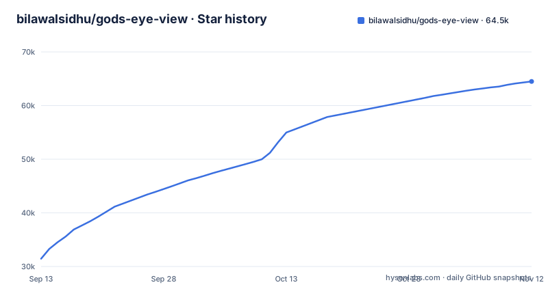
Star history
- bilawalsidhu/gods-eye-view64,503 ★ · +33,057
| Repository | 2026-09-13 | 2026-11-12 |
|---|---|---|
| bilawalsidhu/gods-eye-view | 31.4k | 64.5k |
33,057 Stars in the last 60 days, measured from the daily GitHub snapshot. Compare with other projects
Editorial analysis
The gap between a satellite simulator and a real feed viewer
Most globe demos are either pretty and empty or useful and ugly. God's Eye View sits in between on purpose. The README frames it as a spy-satellite simulator that turns out to be built from public sources: flight transponders, ship beacons, orbital elements, seismographs and public cameras, all placed on the same photorealistic 3D globe. The audience is the person who wants to move from a global picture down to one aircraft, one vessel, or one street without switching tools. That is a narrower claim than it first appears. The README says each layer is a separate module, which tells you where the seams are. If you want a single normalized schema across flights, ships and satellites, this is not that. If you want to see them side by side and click through to metadata, it is.
Cesium plus per-layer modules, and what that means for data flow
The stack is JavaScript on top of Cesium, with WebGL doing the rendering and GLSL shaders used for the sensor looks: CRT, NVG, FLIR/thermal and Noir. Imagery comes from Esri satellite tiles by default, with OSM as the fallback if Esri is unreachable, and keyless terrain. Adding a Cesium ion token upgrades to photorealistic 3D; a Google Maps key is the metered alternative and also enables in-app place search. The README lists what is keyless: flights, military traffic, satellites, earthquakes, public cameras, radio and launches. Click-to-track locks the camera, draws a fading trail and surfaces metadata; a tracked fire or vessel can hand off to the nearest live camera in one click. Share links serialize camera, style, layers and one tracked target into a URL, and the README is explicit that a live target in a link is a handoff rather than a bookmark, because the target keeps moving. That is a small but honest design decision.
Installing it: Pinokio, or Node 24.x and four commands
There are two documented paths. The one-click route needs Pinokio 8.2 or later, then the God's Eye View app page, then Install and Start; the launcher installs locked dependencies, finds a free local port and opens the app, and the README notes the maintainer reports cross-platform testing of the fixed installer on Windows, macOS and Linux. The terminal route is explicit about versions: Node.js 24.x (24.14.0 or later) or 26.x, and the engines range excludes Node 25. The commands are git clone, cd gods-eye-view, npm ci, npm run doctor, npm run dev, and the app opens at http://localhost:4173. Keys are added in the app through a POWER UP panel, which writes the checkout's .env; the README says to start without API keys and add optional keys inside the app.
Where the globe stops being a source of truth
Read the disclaimer carefully, because it is the most important paragraph in the README. Traffic is simulated along real roads using aggregate location data, and CCTV camera poses and rocket launch trajectories are coarse estimates. So three of the more visually striking layers are not measurements of where things are right now. The README also says most feeds are live or regularly refreshed, which is a weaker promise than all feeds are live. Aircraft and vessels in particular are only as good as the public transponders and beacons behind them, and the project does not claim to validate them. Treat any figure here as illustrative. If your work requires authoritative positions, chain of custody, or an uptime commitment, this is the wrong tool, and no amount of shader work changes that.
Non-commercial defaults and the licence ambiguity
GitHub reports the licence as NOASSERTION, meaning it could not map the licence file to a known identifier, while package.json declares "license": "MIT". The README says the bundled Nepal flood data is non-commercial (see DATA_SOURCES.md), so anyone planning to embed this in a product should read LICENSE and DATA_SOURCES.md directly. The imagery has its own constraints. The README states Cesium ion tokens are for eligible personal, non-commercial use, while Google Maps is the direct, metered route, and it adds that provider terms and quotas apply. That matters because the default keyless mode is not a free version of the paid mode; it is a different imagery pipeline with a different fallback path (Esri, then OSM). Upgrading is a licensing decision as much as a visual one.
Compared with dropping the same feeds into a GIS stack
A conventional alternative is to load the same public feeds into QGIS or a self-hosted Cesium or MapLibre viewer headlessly, then style and query them yourself. The difference is in what you get out of the box. God's Eye View ships the interaction layer: cockpit view that holds terrain under a tracked flight, a 250 km contacts roster, detection overlay with screen-space bounding boxes, a military-style HUD, a scene director for camera tours, and a realtime AI agent for hands-free voice control. A GIS stack gives you none of that and asks you to assemble it. In exchange, the GIS path gives you layers you can query, join, and export with reproducible styling. God's Eye View is a presentation surface. If your deliverable is a map product, the GIS route is more work up front and less rework later. If your deliverable is a live view you can talk to, this project has already written the parts you would otherwise spend weeks on.
Maintenance, upgrade cost, and what to verify first
The repository is not archived, and the last push was on 2026-11-02, so there is no staleness signal to weigh. The latest releases are v0.3.0 on 2026-10-28 (Street Level, On Your Phone, in Your Language), v0.2.1 on 2026-10-03 and v0.2.0 on 2026-10-03. A CI workflow exists at .github/workflows/ci.yml, which the README badge references. Upgrade cost is mostly environmental rather than code. The engines range excludes Node 25, so pinning 24.x or 26.x is part of staying current. A fresh clone starts keyless, and the POWER UP panel writes keys to the checkout's .env. Before adopting, verify three things: that npm run doctor passes on your Node version, that your intended use fits the Cesium ion personal, non-commercial terms or a metered Google Maps key, and that the licence file (NOASSERTION on GitHub, MIT in package.json) actually permits what you plan to do with the code.
Editorial conclusion
Adopt God's Eye View if you want a local, inspectable globe for public feeds and you accept that traffic is simulated and camera poses and launch trajectories are coarse estimates. Skip it if you need authoritative tracking, an SLA, or a stable data API, because each layer is a separate module and the feeds themselves are third-party. Before committing, run npm run doctor on Node 24.x or 26.x, confirm whether Cesium ion's personal, non-commercial terms or a metered Google Maps key fit your use, and check the licence file directly, since GitHub marks the repository NOASSERTION (package.json declares MIT) and the README says the bundled Nepal flood data is non-commercial.
Frequently asked questions
What is God's eye view?
In this project it is a browser-based spy-satellite simulator that shows real public data on a photorealistic 3D globe: live aircraft, ships, satellites, earthquakes, traffic, fires and public cameras. It was formerly called WorldView, and it runs locally in the browser with source you can inspect.
Does God's Eye View need API keys to start?
No. Both installation paths open the app with Esri satellite imagery and keyless terrain, with OpenStreetMap as the fallback, and flights, satellites, earthquakes, public cameras, radio and launches are available without keys. Photorealistic 3D needs either a Cesium ion token or a Google Maps key, added later in the POWER UP panel.
Which Node version does God's Eye View run on?
package.json declares an engines range of >=24.14.0 <25 || >=26 <27, so the 24 line from 24.14.0 upward and the 26 line are accepted, and the 25 line is not.
Can I install God's Eye View without a terminal?
Yes, through Pinokio 8.2 or later: install or update Pinokio, open God's Eye View in Pinokio, then click Install and Start. The launcher installs the locked dependencies, finds a free local port and opens the app, and it is available on Windows, macOS and Linux.
Official sources
Where developers are discussing it
Posts on Hacker News, dev.to and Lobsters that link to this repository, found by our scan of those communities. 0 in the last 30 days; newest first.
- God's Eye ViewHacker News · Sep 16, 2026 · 4 points · 0 comments
- A spy satellite simulator in the browser, except the data is realHacker News · Sep 10, 2026 · 2 points · 0 comments
Add this badge to your README
If you maintain this project, the badge below links readers to this analysis and shows its maintenance status from the daily GitHub snapshot. Paste the markdown into your README; add ?metric=license or ?metric=stars to the image URL for a different field.

[](https://hysenlabs.com/projects/bilawalsidhu-gods-eye-view)
[](https://hysenlabs.com/projects/bilawalsidhu-gods-eye-view)Star history chart for your README
[](https://hysenlabs.com/projects/bilawalsidhu-gods-eye-view)Was this useful?