StreetComplete: OpenStreetMap editing narrowed to questions a surveyor can answer
Easy to use OpenStreetMap editor for Android
At a glance
- What is it?
- StreetComplete replaces the tag editor with a question: it finds nearby places that need a survey, puts a marker on the map, and turns whatever you type into an upload on your own OSM account. The constraint that shapes everything is that quests must be answerable by asking a simple question, which is why the hard mapping work is deliberately left to other editors, and why the repository carries its own quest guidelines instead of a plugin architecture.
- Who is it for?
- Adopt StreetComplete if you want to contribute to OpenStreetMap from a phone without learning tagging schemes, and if you survey on foot or on a bicycle where data use matters. Do not adopt it for mapping work that needs expertise: relationship edits, multipolygon geometry and import jobs are outside what a question can express.
- Can I use it commercially?
- Yes, with conditions. GPL-3.0 is a copyleft licence: if you distribute software that includes it, you must release that software's source code under the same licence. Running it internally without distributing it does not trigger that obligation.
- Is it still maintained?
- Yes. The repository last received commits 3 days ago.
- What is it written in?
- Mainly Kotlin, according to GitHub's language statistics.
Answers come from the project's GitHub data, last synced on November 15, 2026, and from our analysis. They are not legal advice.
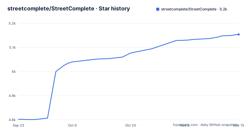
Star history
- streetcomplete/StreetComplete5,154 ★ · +352
| Repository | 2026-09-23 | 2026-11-15 |
|---|---|---|
| streetcomplete/StreetComplete | 4.8k | 5.2k |
352 Stars in the last 53 days, measured from the daily GitHub snapshot. Compare with other projects
Editorial analysis
Every quest has to survive the simple question test
The mechanism is a loop with no editor in it. StreetComplete automatically looks for nearby places where a survey is needed and shows them as quest markers on its map. Each marker can be solved on site by answering a question, and the README's example is the plainest one: tapping a marker may show the question "What is the name of this road?", with a text field to answer it. What follows that answer is the constraint that defines the product. To keep the app easy to use, quests are limited to those answerable by asking simple questions, which means the app will never ask you something you need expertise to judge. There are quite a few quest types now and more are added over time, and the full list lives in the OSM wiki under community management rather than in the app. Two things follow from that design. Nothing in the app is a tagging dropdown you have to learn, so the learning curve is the questions themselves rather than the ontology. And the cases that need judgement are absent on purpose, which means the tool that helps you is not the tool you reach for when a relation has to be split.
Answers become changesets under your own OSM account
There is no draft queue and no export step. The user's answer is automatically processed and uploaded directly into the OSM database, and edits are done in meaningful changesets using the user's OSM account. That last clause is the part to sit with before you start: your account is the authorship of every edit, the same as if you had typed them in a desktop editor, and a group of low-value answers uploaded over an afternoon is indistinguishable from one made deliberately. Because the answers are structured rather than free text, the changeset is still readable afterwards, which is what makes the pattern survivable in a database other people maintain. Since the app is meant to be used on a survey, it also works offline and is economical with data usage.
Quest design is governed by two documents in the repository
Adding a question is treated as a contribution in its own right, not as a feature request. The tree carries `QUEST_GUIDELINES.md` and a separate `CONTRIBUTING_A_NEW_QUEST.md`, next to `CONTRIBUTING.md` and `OVERLAY_GUIDELINES.md` for overlays. The quest list itself is community managed and lives in the wiki, so the authoritative count of what exists is not in the repository at all. For a project that also lets people suggest a quest without writing any code, this split matters: the rule set that keeps questions answerable is written down, and the current catalogue is somewhere else entirely. `AUTHORS.md` and `CHANGELOG.md` sit alongside them, with the release notes linked from the README as the place to see what changed.
Android is shipped, iOS is an alpha from a migration in progress
The download section offers four channels. Google Play carries the app under the package name `de.westnordost.streetcomplete`, F-Droid hosts a build, the GitHub releases page holds the latest artifact, and a TestFlight link covers iOS. Recent releases are v64.0-beta2 on 2026-10-10, v64.0 on 2026-10-19 and v64.1 on 2026-11-01, with the last push dated 2026-11-01. The README describes the app as available for Android and iOS. The tree explains why: `androidApp/` and `iosApp/` sit beside a shared `app/` module, with `build.gradle.kts`, `settings.gradle.kts`, `buildSrc/`, `gradle.properties` and the `gradlew` wrapper, which is the shape of a codebase being reorganised around shared code rather than two separate applications.
Four NLnet grants and two Prototype Fund rounds paid for the iOS work
The funding section is unusually specific, and it explains the state of the project better than a roadmap would. The NLnet foundation sponsored development in four individual grants with funds from the European Commission. A grant from 2025 lets Tobias Zwick finish migrating the app to a multiplatform so it runs on iOS as well, tracked as ticket 5421. A 2021 grant enabled about five months of work on the app, most notably the overlays functionality and measuring with AR. Mateusz Konieczny received grants in 2019 and 2021 focused on UI improvements and data collection. Before that, Prototype Fund round 15, from March 2024 to August 2024, sponsored the earlier iOS work, and round 8 from September 2020 to February 2021 focused on collecting more data points. The OpenStreetMap foundation funded Map Maintenance with StreetComplete in August 2020 through its microgrants.
The background map is a donation, and it is load bearing
Since mid 2020, JawgMaps has provided the vector map tiles service for StreetComplete for free, which is the background map displayed in the app. One sentence in a sponsorship section, and it is the most consequential dependency in the project: the tool you use to answer questions about what is physically in front of you draws its map from a service another company donates. Individual users support ongoing work through GitHub sponsors, Liberapay and Patreon.
You can contribute without writing Kotlin
The contributing guide makes the point that you can take part without programming or OpenStreetMap knowledge, and the tasks are listed as routes rather than wishes. Testing and reporting issues is the first, and it has its own anchor in `CONTRIBUTING.md`. Translating the app is the second, and with a user base spread across languages that is continuous work rather than a one-off. Solving notes left by StreetComplete users is the third, which is a data cleaning job: other people flagged something and nobody has looked at it. Then there is suggesting new quests, and implementing them if you would rather write the code, which is where `CONTRIBUTING_A_NEW_QUEST.md` takes over. The primary language in the repository is Kotlin, and only implementing quests requires touching it. The repository is licensed GPL v3.0 only, and `.editorconfig`, `.gitattributes` and `.idea/` sit at the top level next to the two contributing guides.
Editorial conclusion
Adopt StreetComplete if you want to contribute to OpenStreetMap from a phone without learning tagging schemes, and if you survey on foot or on a bicycle where data use matters. Do not adopt it for mapping work that needs expertise: relationship edits, multipolygon geometry and import jobs are outside what a question can express. Check the community quest list before you build survey habits around a specific question type.
Frequently asked questions
What does StreetComplete do while you are out surveying?
It looks for nearby places where a survey is needed and shows them as quest markers on its map. Tapping a marker asks a simple question, such as the name of this road, and the answer is processed and uploaded directly into the OpenStreetMap database.
Do I need OpenStreetMap tagging knowledge to use StreetComplete?
No. The app is aimed at users who do not know anything about OSM tagging schemes but still want to contribute, and quests are limited to those answerable by asking simple questions. Mapping work that needs expertise is left to other editors.
Is StreetComplete available on iOS?
Yes. The README describes the app as available for Android and iOS and links an iOS build on TestFlight in its download section. A 2025 grant from the NLnet foundation allowed Tobias Zwick to finish migrating the app to a multiplatform so it also runs on iOS, tracked as issue 5421.
How do I install StreetComplete?
Four download channels are listed: the Google Play listing for de.westnordost.streetcomplete, the F-Droid package page, the latest release on GitHub, and TestFlight for iOS. The software is released under the GNU General Public License v3.0 only.
How can I contribute to StreetComplete without writing code?
The contributing guide lists testing and reporting issues, translating the app, solving notes left by other users, and suggesting new quests. There is a separate guide for implementing a quest, CONTRIBUTING_A_NEW_QUEST.md, and quest guidelines at the top of the repository.
Official sources
Where developers are discussing it
Posts on Hacker News, dev.to and Lobsters that link to this repository, found by our scan of those communities. 3 in the last 30 days; newest first.
- StreetComplete iOS ReleaseHacker News · Oct 26, 2026 · 2 points · 0 comments
- StreetComplete v64.0Hacker News · Oct 20, 2026 · 32 points · 6 comments
- StreetComplete v64.0 with iOS Support ReleasedHacker News · Oct 19, 2026 · 2 points · 1 comments
- StreetComplete on iOS is now in public betaHacker News · Oct 1, 2026 · 631 points · 178 comments
Add this badge to your README
If you maintain this project, the badge below links readers to this analysis and shows its maintenance status from the daily GitHub snapshot. Paste the markdown into your README; add ?metric=license or ?metric=stars to the image URL for a different field.

[](https://hysenlabs.com/projects/streetcomplete-streetcomplete)Star history chart for your README
[](https://hysenlabs.com/projects/streetcomplete-streetcomplete)Was this useful?