geointel: a Gemini wrapper whose confidence label is the real risk
GeoIntel using Google's Gemini API to uncover the location where photos were taken through AI-powered geo-location analysis.
At a glance
- What is it?
- Three dependencies, a prompt, and a structured response with a self-reported confidence level attached to coordinates and a maps link, plus a web interface that takes the API key in the browser and a documented example that binds every network interface on a port the next line contradicts.
- Who is it for?
- Adopt geointel as a starting point for image provenance work, where the goal is a lead rather than an answer, because it gives you a structured response you can log and diff and it costs three dependencies. Do not adopt it as a determination, because the confidence field is the model reporting on itself rather than a calibrated probability, and a high label next to coordinates and a maps link carries authority the underlying method cannot support.
- Can I use it commercially?
- Yes. MIT is a permissive licence: you can use, modify and sell software built on it, as long as you keep its copyright and licence notices.
- Is it still maintained?
- Activity is slowing. The repository last received commits 8 months ago.
- What is it written in?
- Mainly HTML, according to GitHub's language statistics.
Answers come from the project's GitHub data, last synced on November 20, 2026, and from our analysis. They are not legal advice.
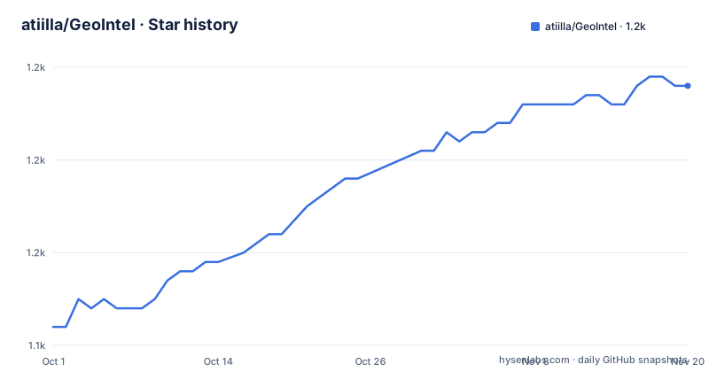
Star history
- atiilla/GeoIntel1,168 ★ · +26
| Repository | 2026-10-01 | 2026-11-20 |
|---|---|---|
| atiilla/GeoIntel | 1.1k | 1.2k |
26 Stars in the last 50 days, measured from the daily GitHub snapshot. Compare with other projects
Editorial analysis
Three dependencies, one prompt, and a model doing all the work
Set expectations before reading anything else, because they shape how you should evaluate this. The install is one package:
pip install geointeland the runtime dependencies are three: an HTTP client, a web framework, and a cross-origin middleware for that framework. There is no computer vision code, no geolocation database, no reverse image search and no model of its own. The tool sends an image to a general-purpose multimodal API and structures what comes back. That is the whole architecture, and it has two consequences. The first is that the accuracy you get is the accuracy of a general-purpose vision model asked a question it was not specialised for, which is a different and lower bar than a model trained for this task. The second is that there is nothing here you cannot do yourself with a few lines against the same API, so the value you are paying for is the response format, the command line surface, the browser interface and the map rendering. That is real value if you want those, and it is thin if you only want coordinates. The command line is the smallest of the three surfaces: an image flag, a context flag for information you supply, a guess flag for a location you suspect, an output flag for a JSON file, and a key flag. The context and guess flags are the interesting ones, because they let you condition the model, which is also the reason a confident answer is easier to produce than a correct one.
The confidence label is the part that will be quoted and the part that is weakest
Read the response format section as a design decision, because the fields are the product. The response carries an interpretation field holding the model's prose analysis, and a locations array where each entry has country, state and city, a confidence level, coordinates as latitude and longitude, and an explanation of the reasoning. The confidence level takes one of three values, high, medium or low. That field is the problem, and it is a problem of the whole class of tool rather than of this implementation. A confidence level reported by the model about its own answer is not a probability. It is a generated token, and it is generated by the same process that generated the city name, so the two are correlated: when the model is confidently wrong about a place it will very often be confident about its reasoning too. The readme itself concedes the underlying accuracy is not guaranteed. What it does not say is that the label makes the output more persuasive than the method deserves, and the surrounding design amplifies that. The SDK example takes the first location, pulls the latitude and longitude, and formats a maps link, so the output of the whole pipeline is a URL that renders a confident pin on a map. A reader who sees a map has already accepted a conclusion. If you use this, keep the JSON and the log, treat the label as prose rather than as a filter, and never let the pin reach a person who has not seen the caveat.
The web interface takes the key in the browser, and the example binds every interface
The web interface is the newest part of this tool and it introduces the only security decision in the project. Its features are listed as drag-and-drop image upload, in-browser API key configuration, an interactive three-dimensional map, and real-time analysis with explanations. The key point is the second one. The key is entered in the browser and the browser sends it to the local server, which holds it for the request. That is a reasonable design for a single-user local tool, and it becomes a different design the moment the server is reachable by anyone else. The readme's example is:
geointel --web --host 0.0.0.0 --port 4000Binding to all interfaces means every host that can route to the machine can now upload an image and spend your key. There is no authentication in the feature list, and the cross-origin middleware in the dependency list makes the browser willing to talk to it. Combined, the exposed service is an unauthenticated proxy to a paid API with your credential in it. The readme then tells you to open the browser to a loopback address on a different port than the one in the example, which is a documentation slip rather than a security control, but it also means the example is untested. The default host is loopback and the default port is a different one, so the safe configuration is the one you get without flags. Use the flags only when you understand what you are opening, and put a reverse proxy with authentication in front of it if you need it on a network.
The web extra adds nothing, and the packaging reaches outside the package directory
Two packaging details in the setup script are worth reading, because both are small and both will cost somebody time. The first is the optional dependency group. The script declares a web extra containing the web framework and the cross-origin middleware, and it also lists both of them as required dependencies. So the extra is empty in effect: there is no installation in which you get the framework and there is no installation in which you do not. That is almost certainly an earlier iteration of the design that was not cleaned up, and the practical cost is that the command line path pulls two web packages for a tool that could be a single HTTP client. It is not a security problem, and it is a sign that the packaging has not been revisited since the interface was added. The second detail is the data file pattern. The script asks for files from the package directory using a pattern that walks up out of it with a parent-directory reference, matching the template directory that sits beside the package at the repository root. Packaging data by reaching outside the package is fragile: the behaviour depends on the build backend and on whether the parent directory happens to be present, and a wheel built in a way that does not include it will install cleanly and then fail when you launch the web interface. If you vendor this, check that the interface assets are actually in the installed wheel before you rely on them.
The packaging metadata claims a model version the readme never mentions
There is a discrepancy between what the package says it is and what the readme documents, and it is the kind that only shows up in search results and package listings. The setup script's description field says the tool uses a specific model generation with multi-model support. The readme says only that the tool uses the provider's API and links to the developer studio for a key, and it never names a model version and never mentions multi-model support. The two sources are not reconcilable from what is visible here, and the package description is the one that appears on the index page where people find you. Either the feature is undocumented or the description is aspirational, and in both cases a reader deciding whether to install has to go to the source to find out. That is worth resolving before you depend on it, and it is cheap to resolve: a sentence in the readme saying which models are supported and how you select one. There is a second documentation-quality signal in the same area, which is the argument table. It is not marked up as a table at all in the readme; the argument names and descriptions are inside a plain code fence, so the column alignment in the source is invisible on the rendered page. It is a small thing, and it is the kind of thing that suggests the readme was written quickly and reviewed once.
A recording, a screenshot and a test photo committed at the repository root
The top-level listing tells you how the project is worked on, and it is a small, flat repository. There is the package, the interface template directory, an examples directory with a usage script and its own requirements file, a requirements file, a setup script, and then three files that belong in documentation or nowhere: a terminal recording committed to the repository, a screenshot, and a photograph. The recording is embedded in the readme through a hosted terminal-recording service, so the file is there twice, once on a third party and once in the repository, which means the same demo cannot be updated in one place. The photograph at the root is presumably a sample input, and it is a reasonable thing to have, though it would be tidier in the examples directory next to the script that uses it. The examples directory having its own requirements file is the detail that suggests real friction: if the example needs different dependency versions from the package, then running the example from a clean environment is a two-step operation, and the readme does not walk through it. The release picture is thin. There are no published releases, the package version is at a beta status, and the last commit to the repository is from March 2026, which is more than six months before now. So treat this as a project in a quiet phase rather than one that will respond to an issue this week.
What the tool is for, and why the disclaimer is the real documentation
There are legitimate uses for asking a model where a photograph was taken, and they are worth naming because they are the reason to keep this category of tool. Verifying the provenance of a news photograph, checking whether an image circulating online is older than it claims, tracing where a publicly posted landscape image was taken for a research purpose, and narrowing a search when a photograph of a public building is ambiguous are all things a human investigator does slowly and a model can do in a second. None of those involve a person who did not choose to be photographed. The set of uses that make this dangerous is almost entirely about people rather than places, and the readme says so in the strongest paragraph in the file: the tool is for education and research, the predictions are not guaranteed accurate, and it must not be used for surveillance, stalking, law enforcement, or anything that infringes privacy or causes harm. Read that paragraph as the specification, because nothing in the code enforces it. There is no filter on the input, no check on the output, and no record of who asked. A tool that takes a photograph of a person and returns coordinates and a map link is, functionally, a doxxing instrument, and the disclaimer is the only thing standing between it and that use. If you are the maintainer, that is the gap worth closing, and the cheapest way to close it is a refusal to produce coordinates for images that appear to contain people. If you are a user, that is the line to hold yourself to, and the useful discipline is to treat every answer as a lead with a confidence note attached rather than as a location.
Editorial conclusion
Adopt geointel as a starting point for image provenance work, where the goal is a lead rather than an answer, because it gives you a structured response you can log and diff and it costs three dependencies. Do not adopt it as a determination, because the confidence field is the model reporting on itself rather than a calibrated probability, and a high label next to coordinates and a maps link carries authority the underlying method cannot support. Two things to check before you expose it to anyone else. Leave the web interface on its default loopback host, because the documented example binds all interfaces and the interface takes the API key in the browser, which turns your local server into an open proxy to your key. And read the disclaimer, which names surveillance and stalking among the prohibited uses and is the most substantive paragraph in the readme, because the tool has no technical control that stops either. If your use is verification of a public image, keep the JSON output and the log, and treat every coordinate as a hypothesis.
Frequently asked questions
How do I install and run geointel?
Install the package with pip, then run it against an image path or URL with the image flag for command line use, or launch the web interface with the web flag. The runtime dependencies are an HTTP client, a web framework and a cross-origin middleware, and the key comes from an environment variable or a command line flag.
What does the geointel response contain?
A structured JSON response with an interpretation field holding the analysis prose, and a locations array whose entries carry country, state and city, a confidence level of high, medium or low, latitude and longitude coordinates, and an explanation of the reasoning.
Can I run the geointel web interface on a network address?
The interface accepts a host flag and a port flag, and the readme's example passes a non-loopback host with a custom port. The default host is loopback, and the feature list includes in-browser API key configuration, so exposing the interface to a network means exposing an unauthenticated proxy to your key.
What are geointel's stated limitations and prohibited uses?
The readme says the tool is for educational and research purposes, that the predictions are not guaranteed to be accurate, and that it must not be used for surveillance, stalking, law enforcement, or any activity that infringes privacy, violates laws, or causes harm. The authors also disclaim responsibility for consequences.
Does geointel use geolocation data of its own?
No. The dependency list is an HTTP client, a web framework and a cross-origin middleware, and the tool sends the image to the provider's API and structures the response. The value it adds is the response format, the command line surface, the browser interface and the map rendering rather than any location data of its own.
Official sources
Add this badge to your README
If you maintain this project, the badge below links readers to this analysis and shows its maintenance status from the daily GitHub snapshot. Paste the markdown into your README; add ?metric=license or ?metric=stars to the image URL for a different field.

[](https://hysenlabs.com/projects/atiilla-geointel)Star history chart for your README
[](https://hysenlabs.com/projects/atiilla-geointel)Was this useful?